LIDAR (Light Detection and Ranging) Bathymetry
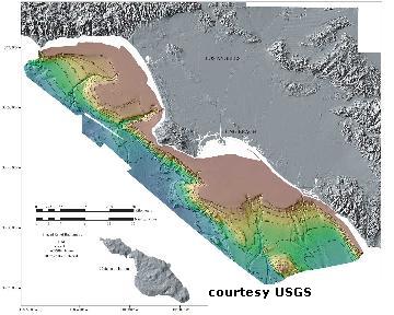 Lidar is a technology that shines large swaths of laser light onto an object and looks at the reflected signal that is bounced back. Just like the policeman that catches you speeding on the freeway bounces radar at your car, the lidar instrument uses laser light. The police detects how fast you are going by using a radar detector to time how long it takes for the transmitted beam to reflected by your car back to his detector. Lidar Bathymetry uses a slight variation of this idea. By flying an airplane over the Earth's surface and shining a pulsed (eye-safe) laser down at a feature such as a mountain, features that are closer to the airplane will reflect back quicker than things that are farther away. This results in the ability to map the surface topography. An adaptation of this technology can be used to map the sea floor. This is called bathymetry. Traditionally the ocean bed is mapped using ships dragging bathymetric instruments. Features in shallow water or close to shore cause hazards to ships and in these instances airborne bathymetry is useful. Like the airborne surveying of a mountain described above, airborne mapping of the sea bed looks at the reflection of pulsed laser light, however with the added complication of sea water interface. Lidar is a technology that shines large swaths of laser light onto an object and looks at the reflected signal that is bounced back. Just like the policeman that catches you speeding on the freeway bounces radar at your car, the lidar instrument uses laser light. The police detects how fast you are going by using a radar detector to time how long it takes for the transmitted beam to reflected by your car back to his detector. Lidar Bathymetry uses a slight variation of this idea. By flying an airplane over the Earth's surface and shining a pulsed (eye-safe) laser down at a feature such as a mountain, features that are closer to the airplane will reflect back quicker than things that are farther away. This results in the ability to map the surface topography. An adaptation of this technology can be used to map the sea floor. This is called bathymetry. Traditionally the ocean bed is mapped using ships dragging bathymetric instruments. Features in shallow water or close to shore cause hazards to ships and in these instances airborne bathymetry is useful. Like the airborne surveying of a mountain described above, airborne mapping of the sea bed looks at the reflection of pulsed laser light, however with the added complication of sea water interface.
AEI was successfully contracted to improve the reliability and provide technology improvements of a bathymetric lidar system. Some of the improvements implemented were camera image enhancements, system reliability and up-time, system re-packaging and weight reduction, operator interface, data storage and software enhancements.
|